For the first time, Afghanistan has established road connectivity with China, across the strategic Wakhan corridor.
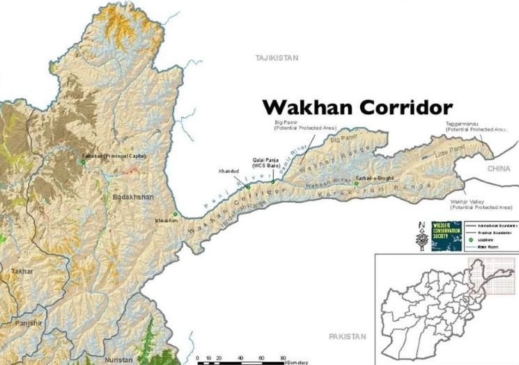
On October 4, the Afghan government inaugurated the 121-kilometer road, stretching from the Boroghil border area to the zero point on the Chinese border in the country’s famous Wakhan district.
In order to cross-over to Xinjiang in China, the Wakhan corridor has to weave through the Wakhjir pass.
More specifically, the Wakhjir pass is the gateway to Tashgurkan, an ancient city along the old Silk Road. Today, Tashgurkan is a hub of China’s Belt and Road Initiative. China reportedly has discussed plans to link the Khunjreb pass of the China-Pakistan border and a part of the China Pakistan Economic Corridor (CPEC), with the Wakhjir pass in the future.
The Wakhjir pass passes through the short, ultra‑remote, high‑altitude border of 76–92 km running entirely along the Mustagh / Pamir watershed at the eastern tip of the Wakhan Corridor.
In fact, the boundary follows a continuous watershed line across the Mustagh, Pamir and Sarikol ranges.
Apart from the Wakhjir passes there is another other pass that threads through the Wakhjir Glacier Valley on the Afghan side and the Chalachigu Valley on the Chinese side.
This is the Tegermansu Pass, which has often been proposed but never activated as the gateway to China.
China has built a 92‑km barbed‑wire fence along the border, with the Keketuluke, ~20 km east of Wakhjir as the border outpost. It has also built a military road, 10 km of the pass.
From the Afghan side, Sarhad‑e Broghil, ~121 km west of Wakhjir is the nearest settlement. The 2026 Wakhan Road ends near the pass but does not create a crossing.
In other words. The Afghanistan–China boundary is a short, extremely high, watershed‑defined frontier running across the Pamir–Mustagh ranges, anchored by the Wakhjir Pass. It is strategically significant, geometrically constrained, and completely closed, with no legal crossing and no civilian access on either side.
Apart from China and the further BRI extension, the Wakhan corridor is strategically important because it shares a border with Tajikistan and Pakistan.
With Tajikistan in the north the Wakhan corridor shares a 100 kilometer long border , defined by the Panj river, which weaves its way across steep river gorge and cliffs. On its part, the Tajik side is known for its high Pamir slopes with no road access to the riverbank.
The nearest Tajik road is the Pamir Highway (M41), 20–40 km north of the river.
Regarding Pakistan, the border runs across the Hindu Kush / Pamir crest at the Broghil Pass at a height of 3,800–4,100 m. In fact, this is the only place where the Wakhan Corridor touches Pakistan, with only 25–30 km of contact length.
While 12i kilometer road, still unpaved has been inaugurated, it is only a part of the 350 km long, ultra‑narrow, high‑altitude east–west corridor that funnels Afghanistan toward China through a sequence of four distinct geomorphological basins and ends at the Wakhjir Pass, a glaciated saddle at ~4,923 m.
The corridor climbs in a steady, stair‑step pattern starting with Ishkashim valley, located at an elevation 2,600 m. The next nodal point is Qala‑e Panja (3,000 m), where the valley begins to shrink.
The Sarhad‑e Broghil (3,300–3,400 m) is the next marker— the roadhead for the new 2026 route. Further east is Little Pamir (3,600–4,000 m) — plateau zone before the formidable Wakhjir Glacier Valley (4,300–4,700 m) is approached, marked by a steep ascent. The final destination is Wakhjir Pass (4,923 m) — the icy glacial trough leading into Xinjiang’s Tashkurgan region.
Despite the tough terrain, the Wakhan corridor when fully developed as a connectivity node can radiate in several directions. With China, the corridor can hinge on the BRI project, opening access to China and broader.
But simultaneously it can become a spur of the International North South Transport Corridor (INSTC), with the Chabahar on Iran’s Indian Ocean coast heading in the direction of Central Asia via Afghanistan and Tajikistan. Such a route will avoid passage through Pakistan and China.
The Wakhan route will supplement the existing road from Chabahar into Afghanistan, with an extension heading to Hairatan which is connected to the Uzbekistan rail, which links to Kazakhstan and Russia, INSTC’s northern branch.
In other words, the Wakhan Corridor can be geometrically integrated into both INSTC’s northern rail branch via Hairatan and INSTC’s southern maritime branch via Chabahar.
While these are clear long-term possibilities, acquiring urgency especially after new question marks have emerged on maritime trade routes following the Hormuz crisis, there are formidable hurdles that need to be overcome.
For instance, China keeps the border across the Wakhjir pass as fully sealed. Without China’s cooperation, Wakhan cannot become an east–west trade corridor.
Despite the inauguration of the new 121‑km road to Wakhjir, this passage is not connected with the rest of Afghanistan’s highway network. Its rail corridors are also poorly developed, preventing Afghanistan from leveraging its unique geography.
In the short term too, China and Afghanistan may have to quickly develop customs or border‑processing facilities at Wakhjir Pass. Besides, the newly built road needs to be quickly paved, especially as it passes through extreme terrain.